US51EIS

US 51 Environmental Impact Statement

  • Home
    • Related Links
    • About This Site
  • Overview
    • Phase 1 (Current)
    • Phase 2
    • Phase 3
  • Information
    • Project Update
    • Public Hearings
    • Vandalia Public Meeting
    • Public Meeting #6
    • Public Meeting #5
    • Public Meeting #4
    • Public Meeting #3
    • Public Meeting #2
    • Public Meeting #1
    • Newsletters
    • Documents
      • Project Information
      • DEIS
      • Public Hearings
      • Public Information Meetings
      • CAG Meetings
    • Frequently Asked Questions
  • Involvement
    • Regional Advisory Group
    • CAG – Ramsey
    • CAG – Vandalia
    • CAG – Vernon / Patoka
    • CAG – Sandoval
    • CAG – Centralia
  • Get Involved
    • Keep Me Informed
    • Tell Somebody
    • Request a Speaker
  • Maps
    • Interactive Map
    • Downloads
  • Contact Us

Overview

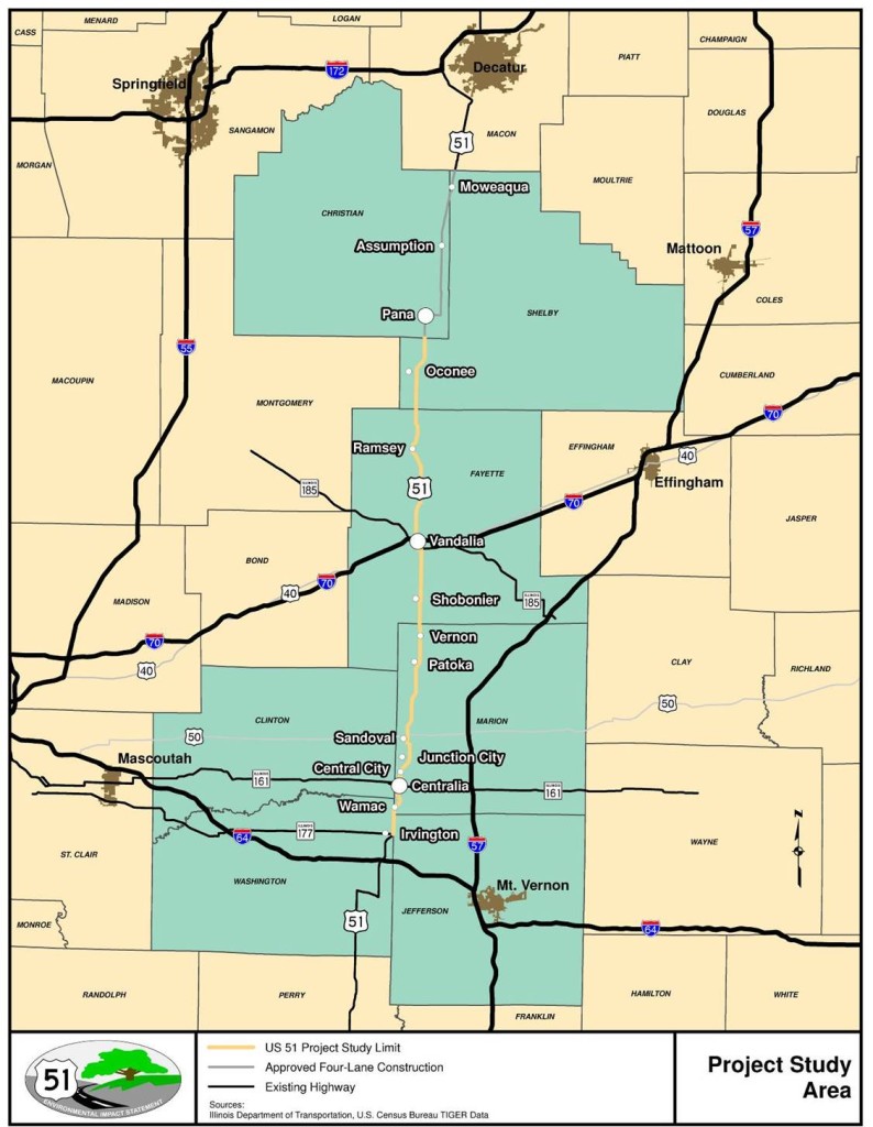
The US Route 51 Environmental Impact Statement (EIS) is being conducted by the Illinois Department of Transportation (IDOT) with the purpose of evaluating the feasibility of several alignments based on social, economic, environmental and engineering issues.  The limits of the study extend from U.S. CR 900 N (south of Pana, IL) south to the CR 2150 N (east of Irvington).  The study area for this project includes the counties of Shelby, Christian, Fayette, Washington, Jefferson, Marion, and Clinton.

Increases in US 51 traffic volumes, operational issues, State economic initiatives and complete or nearly complete four-lane expansion projects to the north of the study area have prompted an urgency to revisit the investigation of upgrading this section of US 51 to a four-lane facility.  The goal of this EIS is obtain a Record of Decision (ROD) that identifies a Preferred Alternative for a transportation improvement that will address identified transportation needs.

Project Study Area Map

Copyright © 2025. US 51 Environmental Impact Statement.